By Ali Sarhadi, Georgia Institute of Technology | –
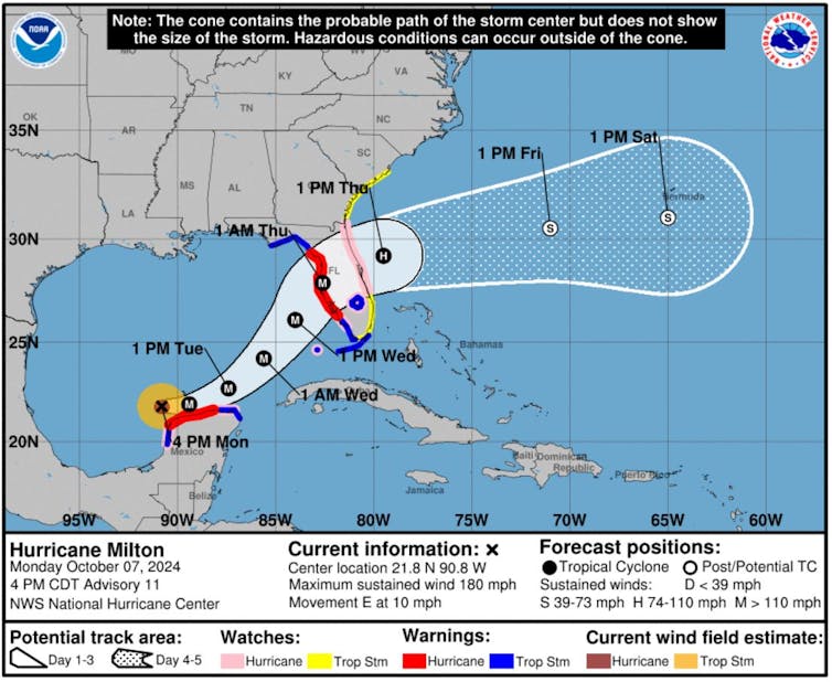
(The Conversation) – Hurricane Milton went from hurricane strength to a dangerous Category 5 storm in less than 24 hours as it crossed the Gulf of Mexico toward Florida.
As wind speeds increased, Milton became one of the fastest-intensifying storms on record. And with sustained winds of 180 mph on October 7, 2024, and very low pressure, it also became one of the strongest storms of the year.
Less than two weeks after the devastating impact of Hurricane Helene, this type of storm was the last thing Florida wanted to see. Hurricane Milton was expected to make landfall as a major hurricane late October 9 or early October 10 and had already prompted widespread evacuations.

National Hurricane Center
So what exactly is rapid intensification and what does global climate change have to do with it? We research hurricane behavior and teach meteorology. Here’s what you need to know.
What is rapid intensification?
Rapid intensification is defined by the National Weather Service as an increase in a tropical cyclone’s maximum sustained wind speed of at least 30 knots – about 35 mph over a 24-hour period. This increase can be enough to move a storm from Category 1 to Category 3 on the Saffir-Simpson scale.
Milton’s wind speed went from 80 mph to 175 mph from 1pm Sunday to 1pm Monday and its pressure dropped from 988 millibars to 911.
The National Hurricane Center had warned that Milton could become a major hurricane, but this type of rapid intensification can catch people by surprise, especially when it occurs near land.
Hurricane Michael caused billions of dollars in damage in 2018 when it quickly intensified into a Category 5 storm shortly before hitting near Tyndall Air Force Base in the Florida panhandle. In 2023, Hurricane Otis’ maximum wind speed increased to 100 mph less than 24 hours before hitting Acapulco, Mexico. Hurricane Ian also intensified rapidly in 2022 before hitting just south of where Milton is expected to cross Florida.
What causes hurricanes to intensify quickly?
It is difficult to predict rapid intensification, but there are some driving forces.
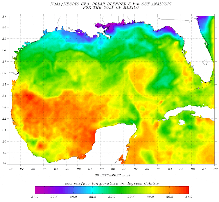
- Ocean heat: Warm sea surface temperatures, particularly as they extend into deeper layers of warm water, provide the energy needed for hurricanes to intensify. The deeper the warm water, the more energy a storm can draw on, increasing its strength.

NOAA
-
Low wind shear: Strong vertical wind shear – a rapid change in wind speed or direction with height – can disrupt the organization of a storm, while low wind shear allows hurricanes to grow more quickly. In Milton’s case, atmospheric conditions were particularly favorable for rapid intensification.
-
Moisture: Higher sea surface temperatures and lower salinity increase the amount of moisture available to storms, fueling rapid intensification. Warmer waters provide the heat needed for moisture to evaporate, while lower salinity helps trap heat near the surface. This allows more sustained heat and moisture to transfer to the storm, resulting in faster and stronger intensification.
-
Thunderstorm activity: Internal dynamics, such as bursts of intense thunderstorms within a cyclone’s rotation, can rearrange a cyclone’s circulation and lead to rapid increases in strength, even when other conditions are less than ideal.
Research has found that globally, most Category 3 and higher hurricanes tend to experience rapid intensification over their lifetimes.
How does global warming affect the strength of hurricanes?
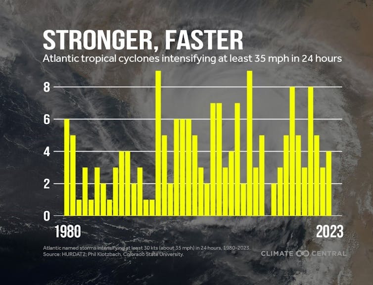
If it seems like we’ve heard a lot more about rapid intensification in recent years, that’s partly because it’s happening more often.

Central Climate, CC BY-ND
A 2023 study investigating the connections between rapid intensification and climate change found an increase in the number of tropical cyclones experiencing rapid intensification over the past four decades. This includes a significant increase in the number of rapidly intensifying hurricanes multiple times during their development. Another analysis that compared trends from 1982 to 2017 with climate model simulations found that natural variability alone could not explain these increases in rapidly intensifying storms, pointing to a likely role of human-induced climate change.
How future climate change will affect hurricanes is an area of active research. However, as global temperatures and oceans continue to warm, the frequency of major hurricanes is expected to increase. Extreme hurricanes in recent years, including Beryl in June 2024 and Helene, are already raising alarms about the growing impact of warming on the behavior of tropical cyclones.![]()
Zachary Handlos, atmospheric science educator, Georgia Institute of Technology and Ali Sarhadi, assistant professor of atmospheric science, Georgia Institute of Technology
This article is republished from The Conversation under a Creative Commons license. Read the original article.
#CO2driven #climate #change #Hurricane #Milton #blow #Cat #category #heads #Florida